The short version
Complete day-by-day breakdown of the Annapurna Circuit — 15 to 21 days, every village, altitude, accommodation, and what to expect at Thorong La Pass (5,416m).
- The classic circuit is a 160–230 km counter-clockwise loop over Thorong La (5,416 m), taking 15–21 days from Besisahar to Pokhara.
- Two permits are required: ACAP ($30) and TIMS ($10), obtainable in Kathmandu or Pokhara.
- The acclimatisation day in Manang (3,519 m) is non-negotiable — never skip it, and attend the 3pm HRA altitude lecture.
- Budget USD $25–$40/day in teahouses; carry insurance covering helicopter evacuation above 5,000 m.
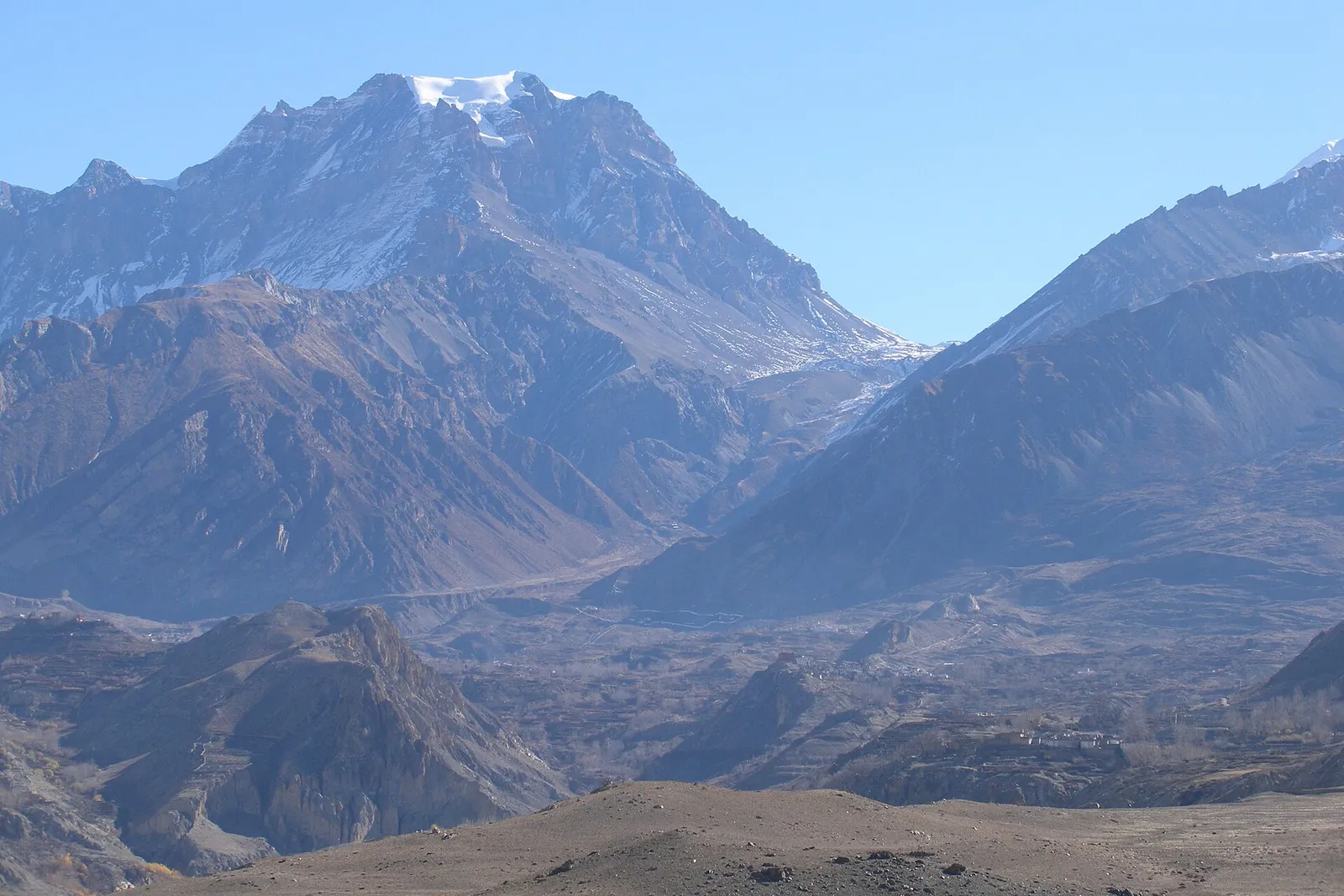
The Annapurna Circuit is one of the world's great mountain walks — a 160–230 km loop through the Annapurna massif that takes you from subtropical river valleys at 800m up to the wind-scoured heights of Thorong La Pass at 5,416m before descending into the arid rain-shadow landscape of Mustang. In 2026, the full classic circuit takes 15 to 21 days depending on your acclimatisation pace, side trips, and whether you walk every stage or use the jeep road shortcuts that have changed the lower sections. This guide breaks down every day, every village, every altitude gain — so you know exactly what to expect before you lace up your boots.
Quick Facts
- Total distance: 160–230 km (varies by route choices)
- Duration: 15–21 days
- Highest point: Thorong La Pass, 5,416m
- Start point: Besisahar (or Bhulbhule) — 6–7 hrs from Kathmandu by bus/jeep
- End point: Pokhara (via Jomsom or Tatopani)
- Permits required: ACAP (Annapurna Conservation Area Permit, $30 USD) + TIMS card ($10 USD)
- Best season: October–November (peak) and March–April (shoulder/spring)
- Daily teahouse cost: $20–$40 USD per person (room + meals)
- Fitness level: Moderate to challenging — no technical climbing required
- Minimum age recommended: 12+ (no hard rule, guide discretion)
Before You Start: Permits and Logistics
In 2026, every trekker on the Annapurna Circuit needs two permits: the Annapurna Conservation Area Permit (ACAP) at $30 USD and the Trekkers' Information Management System (TIMS) card at $10 USD. Both can be obtained at the Nepal Tourism Board offices in Kathmandu (Pradarshani Marg, near Bhrikutimandap) or in Pokhara (Damside). Bring two passport photos and a copy of your passport bio page. For a full breakdown of fees, checkpoint locations, and what the cards cover, see the Annapurna ACAP + TIMS permit guide. If you are coming from abroad, sort your Nepal tourist visa in advance — the e-visa costs $30 USD for 15 days or $50 USD for 30 days and is processed at immigration.nepalgovernment.gov.np.
The Classic Route at a Glance
The circuit is walked counter-clockwise — Besisahar to Manang, over Thorong La, down to Muktinath, and out via Jomsom to Pokhara. This direction means you gain altitude gradually on the longer eastern flank (the Marshyangdi valley), giving your body maximum time to acclimatise before the pass. Going clockwise is possible but not recommended: the ascent from Muktinath to Thorong La is steep, short, and brutal for acclimatisation.
Besisahar → Manang → Thorong La → Muktinath lets you gain altitude gradually up the long Marshyangdi valley, maximising acclimatisation before the pass. The clockwise ascent from Muktinath is steep, short, and dangerous for acclimatisation.
Day-by-Day Itinerary
Day 1 — Kathmandu to Besisahar (760m)
Take an early morning tourist bus or private jeep from Kathmandu to Besisahar — approximately 6–7 hours via the Prithvi Highway. Besisahar is the administrative hub of Lamjung district and the traditional start of the circuit. Arrive, check into a teahouse, collect your permits if you have not already, and rest. The altitude here is a gentle 760m — use the evening to organise your kit and brief your guide if you have one.
Day 2 — Besisahar to Bahundanda (1,310m) | ~4–5 hrs
The first walking day follows the Marshyangdi River north through terraced rice paddies and small Gurung villages. The jeep track now runs alongside much of this section; most trekkers prefer to stay on the original footpath above the road. Bahundanda (meaning "Hill of the Brahmins") sits on a ridge with sweeping valley views — a satisfying first camp at 1,310m.
Day 3 — Bahundanda to Chamje (1,430m) | ~5 hrs
A moderate day through forests of sal and banana trees, crossing several suspension bridges over the roaring Marshyangdi. The valley narrows into a gorge as you approach Chamje — the teahouses here are simple but the setting, wedged between vertical rock walls, is dramatic.
Day 4 — Chamje to Dharapani (1,960m) | ~5–6 hrs
Today you officially enter Manang district and the Annapurna Conservation Area. The landscape shifts — subtropical greenery gives way to drier pine forest and the first Tibetan-influenced architecture. Dharapani (1,960m) marks the junction where a trail branches left toward the Naar Phu Valley (a restricted-area side trek requiring a special permit). Check your ACAP card at the checkpoint here.
Day 5 — Dharapani to Chame (2,710m) | ~5 hrs
Chame is the district headquarters of Manang and the first town with reliable ATMs, pharmacies, and a proper market. Stock up on snacks and batteries. The Marshyangdi valley is now lined with apple orchards, and on clear mornings the summit of Lamjung Himal (6,983m) appears to the south. You are now at 2,710m — mild altitude effects (headaches, disrupted sleep) can begin here; stay hydrated and walk slowly.
Day 6 — Chame to Pisang (3,300m) | ~5–6 hrs
One of the most visually rewarding days on the circuit. The trail passes beneath a spectacular 1,500m-high curved rock face — a natural rock climbing wall — before opening into the wide Pisang Valley with the first jaw-dropping views of Annapurna II (7,937m). There are two Pisang villages: Lower Pisang on the main trail and Upper Pisang (3,300m) perched above on a ridge with a 300-year-old monastery. Stay in Upper Pisang if your legs allow — the monastery walk at sunset is worth every step.
Day 7 — Pisang to Manang (3,519m) | ~5–6 hrs (via Upper Route)
The upper route via Ghyaru (3,730m) and Ngawal (3,660m) is longer and harder than the valley floor path but offers arguably the finest panorama on the entire circuit: Annapurna II, III, IV, and Gangapurna arranged in a single sweeping arc above you. Both routes converge at Manang — spend the afternoon resting and exploring the village. At 3,519m, Manang is large enough to have a proper bakery, a cinema (yes, really — it screens trekking films nightly), and a staffed Himalayan Rescue Association aid post offering free altitude-sickness lectures every afternoon at 3pm. Attend the lecture. It could save your life.
Day 8 — Acclimatisation Day in Manang (3,519m)
Do not skip this day. Spend it hiking to the Gangapurna Glacier viewpoint (3,900m) or Ice Lake (4,600m — a full-day option for fit trekkers), then descend to sleep at the same altitude. The golden rule of high-altitude trekking: climb high, sleep low. Your body's red blood cell production needs this rest day before the push to 5,000m+.
The acclimatisation day at Manang (3,519 m) is essential before the push above 5,000 m. Climb high to Gangapurna viewpoint or Ice Lake, then sleep low — and attend the free Himalayan Rescue Association altitude lecture at 3pm. Rushing this stage is the main cause of AMS turn-backs.
Day 9 — Manang to Yak Kharka (4,018m) | ~3–4 hrs
A short but important day — the altitude gain is modest but your body is working hard to acclimatise. The trail climbs above the treeline through sparse scrub and yak pasture. Yak Kharka is a bare-bones collection of teahouses at 4,018m; evenings are cold and the menu is limited to dal bhat and noodles. The night sky, however, is extraordinary.
Day 10 — Yak Kharka to Thorong Phedi / High Camp (4,450m / 4,850m) | ~3–4 hrs
Thorong Phedi (4,450m) is the base camp below the pass, but most trekkers now continue up to High Camp at 4,850m to shorten the following day's brutal pre-dawn climb. High Camp teahouses fill up quickly in peak season — arrive by early afternoon to secure a bunk. Eat well, drink three litres of water, and sleep by 8pm. Your alarm will be set for 3:30am.
Day 11 — High Camp over Thorong La Pass (5,416m) to Muktinath (3,800m) | 7–8 hrs
This is the day the entire trek builds toward. Leave High Camp by 4am to reach the pass before the afternoon winds arrive. The climb is 566m of steep, rocky switchbacks in pre-dawn darkness — use trekking poles, move slowly, and watch for signs of acute mountain sickness (AMS): severe headache, vomiting, loss of coordination. The pass itself, marked by a stone wall and prayer flag towers, arrives after approximately 3–4 hours of climbing. The view from 5,416m — Dhaulagiri (8,167m) to the west, Thorong Peak above — is the payoff for every hard metre. The descent to Muktinath is a knee-grinding 1,616m drop over loose scree and stone trail; trekking poles are essential. Muktinath at 3,800m is a sacred Hindu and Buddhist pilgrimage site with a famous flame-and-water temple. You have crossed the Himalayas. Celebrate with a hot meal and a real bed.
Day 12 — Muktinath to Jomsom (2,720m) | ~5–6 hrs (or 1 hr by jeep)
The trail descends through the arid, wind-sculpted landscape of the Kali Gandaki valley — the world's deepest gorge by some measures, flanked by Dhaulagiri and Annapurna I. The valley floor is a river of grey sand blasted by afternoon winds that begin around 11am and make walking miserable. Leave early. Kagbeni (2,810m) is a medieval walled village worth a one-hour detour. Jomsom is the district capital with an airport (weather-permitting flights to Pokhara, ~30 min, ~$180 USD) and good teahouses. Many trekkers fly or take a jeep from Jomsom to Pokhara — this is a valid choice after 12 hard days.
Days 13–15 — Jomsom to Pokhara via Tatopani and Poon Hill (optional extension)
If your knees and schedule allow, walking out through Tatopani (1,190m), famous for its natural hot-spring pools, and ascending to Poon Hill (3,210m) for the classic Annapurna sunrise panorama adds 3 days and rounds out the experience beautifully. From Ghorepani, a short bus or jeep ride brings you to Pokhara. Alternatively, take a direct jeep from Jomsom to Pokhara (5–6 hrs, ~$20–25 USD) on a combination of paved and dirt road. For what to do once you arrive, see our Pokhara travel guide.
Teahouse Costs and What to Budget
In 2026, the Annapurna Circuit remains one of Nepal's best-value treks. Teahouse accommodation ranges from $5–15 USD per night for a basic twin room (some teahouses offer free rooms if you eat all meals there). Meals run $4–8 USD each — dal bhat is always the best value and comes with unlimited refills. Budget $25–40 USD per person per day all-in, rising to $35–50 USD at High Camp and Thorong Phedi where prices reflect the supply logistics. A full 15-day circuit costs roughly $400–600 USD in teahouse expenses, plus $40 USD in permits, plus flights/transport from/to Kathmandu. Hiring a licensed guide costs $30–40 USD per day and is strongly recommended for the Thorong La section and for navigating the route changes from jeep road construction. See the full Annapurna Circuit tour packages for guided options with all logistics handled, and our Nepal trekking cost guide for a complete budget breakdown.
What Has Changed in 2026
The jeep road that now runs from Besisahar to Manang has permanently altered the lower circuit. The original footpath from Tal to Dharapani still exists and is beautiful, but several villages between Besisahar and Chame have been bypassed by trekkers taking jeeps to start at Dharapani or Chame directly — saving 3–4 days and skipping some of the finest Gurung village walking. The upper section from Manang onward remains road-free and unchanged. Our strong recommendation: walk every day from at least Dharapani northward, and use the jeep only if your schedule genuinely requires it. The Annapurna Circuit trek guide covers current trail conditions and road-section updates.
Frequently Asked Questions
How difficult is Thorong La Pass?
Thorong La (5,416m) is not technically difficult — there is no glacier travel or fixed rope — but the altitude makes it genuinely challenging. The pre-dawn start, the 566m climb from High Camp, and the 1,616m descent to Muktinath all in one day is a serious physical undertaking. Strong cardiorespiratory fitness, proper acclimatisation (two nights at Manang minimum), and early departure are the keys to a safe crossing. Roughly 5–10% of trekkers develop AMS symptoms serious enough to turn back; go with a guide who can recognise the signs.
What is the best time of year to trek the Annapurna Circuit?
October and November offer the most stable weather and clearest mountain views after the monsoon clears. March and April are equally good for views and the added spectacle of rhododendron forests in bloom. December through February is cold but passable with the right gear — Thorong La can be closed after heavy snowfall, sometimes for several days. The monsoon months of June through September bring leeches, mist, and trail landslides; the circuit is not closed but conditions are significantly harder.
Can I trek the Annapurna Circuit without a guide?
Yes — the circuit is one of Nepal's few routes where independent trekking is still officially permitted. The trail is well-marked and teahouses are plentiful. That said, a guide adds real value: they know trail conditions after storms, can negotiate with teahouse owners in busy season, carry a pulse oximeter, and can organise emergency evacuation. For solo trekkers or first-time high-altitude walkers, we strongly recommend at least a guide for the Manang-to-Muktinath section. Register your trek with the TIMS system regardless — checkpoints record your progress.
How long does the Annapurna Circuit take?
The minimum responsible duration is 15 days including the acclimatisation day in Manang. Rushing to 12 days is possible but significantly increases AMS risk and cuts out the best high-altitude walking days. Twenty to 21 days allows for side trips to Tilicho Lake (4,919m — a breathtaking detour of 2–3 days from Manang), Naar Phu Valley, and a leisurely exit via Poon Hill. Most trekkers complete the circuit in 16–18 days.
Do I need travel insurance for the Annapurna Circuit?
Travel insurance with helicopter evacuation coverage is essential, not optional, for any Himalayan trek. Helicopter rescue from Thorong Phedi or Manang costs $3,000–6,000 USD and must be pre-authorised by your insurer. Policies from World Nomads, True Traveller, or Battleface that cover trekking above 5,000m are widely accepted by Nepali rescue operators. Carry your insurer's emergency number on your phone and on a laminated card in your pack. The guides section has a full checklist of what your policy must cover for Nepal trekking.
How many days do I need for the Annapurna Circuit?
The minimum responsible duration is 15 days, including the Manang acclimatisation day. Most trekkers take 16–18 days; 20–21 days allows side trips like Tilicho Lake and a Poon Hill exit. Rushing to 12 days sharply raises AMS risk.
Has the jeep road ruined the Annapurna Circuit?
Not the best parts. A road now runs Besisahar to Manang, so many trekkers jeep to Dharapani or Chame to save 3–4 days. The upper section from Manang over Thorong La remains road-free and unchanged — walk from at least Dharapani northward for the finest experience.
Featured image: Vyacheslav Argenberg via Wikimedia Commons (CC BY 4.0).
Book Your Trek
Annapurna Circuit Trek — Full-Service Packages
From 13-day classic circuit to custom variations — ACAP permits, licensed guides, and tea house accommodations all arranged. Pokhara-based since 1998.
View Annapurna Circuit →Written by
Travel Himalaya Nepal
Pokhara-based, NMA-certified trekking guides. We’ve led 5,000+ treks across the Annapurna and Everest regions since 1998 — every word here comes from the trail. Meet the team →
Share this article
Ready to Trek?
From reading about it to standing on it
Our Pokhara-based guides have been doing this since 1998. Tell us your dates and fitness level — we'll build your perfect itinerary. Free, no obligation.
Popular treks to consider
Free Trekker's Insider Guide
Permits, packing lists, cost breakdowns — no fluff.
We send one useful email. You can unsubscribe anytime.