The short version
Add Tilicho Lake (4,919m) to the Annapurna Circuit: the route, extra days, difficulty, acclimatisation and 2026 cost — a guide-led plan for the side-trip.
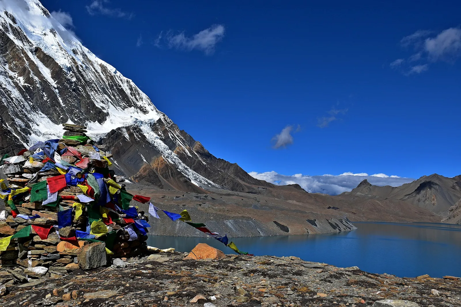
Tilicho Lake sits at 4,919m in a glacial amphitheatre below the Tilicho Peak — one of the highest large lakes anywhere on earth. Bolting it onto the classic Annapurna Circuit is, in our opinion, the single best upgrade you can make to the trek: two to three extra days for a turquoise sheet of ice-melt that most circuit walkers never see. Here is exactly how the side-trip works, what it adds in difficulty and cost, and how we acclimatise our groups to do it safely.
- What it is: a 2–3 day detour from Manang/Khangsar out to Tilicho Lake (4,919m) and back, before rejoining the Circuit for Thorong La (5,416m).
- Total trip: typically 17–19 days door-to-door versus 12–14 for the standard Circuit.
- Difficulty: strenuous — the Shree Kharka to Tilicho Base Camp landslide traverse is the crux of the whole trek.
- Permits: no extra paperwork — your ACAP (and TIMS, where checked) already cover Tilicho.
- Cost: roughly US$1,300–2,300 per person guided, season and group size depending.
Why add Tilicho to the Annapurna Circuit?
The standard Annapurna Circuit is already one of the great walks of the world — a full loop through subtropical valleys, pine forest, high desert and a 5,416m pass. But it bypasses Tilicho entirely. The lake hangs in a hidden side-valley west of Manang, ringed by the Grand Barrier of Tilicho, Nilgiri and Khangsar Kang. When the water is frozen in autumn it glows an unreal blue-grey; later in the season it reflects the peaks like a mirror.
There is also a practical argument. The out-and-back to Tilicho Base Camp gives your body two extra high days around 4,100–4,900m before you ever attempt Thorong La. Done sensibly, the detour improves your acclimatisation for the pass rather than tiring you out — which is why we build it into our 17-day Annapurna Circuit with Tilicho Lake itinerary.
The route: where the detour begins and ends
You follow the normal Circuit up the Marsyangdi valley — Besisahar, Chame, Pisang — to Manang (3,540m), the great acclimatisation hub of the trek. Instead of pushing straight on toward Yak Kharka and the pass, you branch southwest:
- Manang → Khangsar (3,734m) — a short half-day to the last permanent village before the lake valley.
- Khangsar → Shree Kharka → Tilicho Base Camp (4,150m) — the committing day. The trail traverses a long, exposed landslide and scree slope; this is the technical and psychological crux of the whole trek.
- Base Camp → Tilicho Lake (4,919m) → back to Base Camp or Shree Kharka — a pre-dawn start, roughly 3–4 hours up to the lake, time at the shore, then a long descent.
From there you rejoin the main Circuit at Yak Kharka and continue to Thorong Phedi, over Thorong La (5,416m), down to Muktinath and out via Jomsom or Tatopani. So Tilicho is a clean side-trip that slots in before the pass, not a separate trek.
The path from Shree Kharka to Tilicho Base Camp crosses a notorious active landslide of loose scree. It is normally fine in stable dry weather but genuinely dangerous in rain, fresh snow or strong wind. Our guides time this crossing for the early morning when the slope is cold and rockfall is least active — local knowledge here is not optional.
How many extra days does it add?
Against a 12–14 day Circuit, Tilicho realistically adds 2–3 days: one to reach Base Camp via Khangsar, one for the lake and return, and often a built-in buffer day for weather or a second acclimatisation night. That is why most quality Tilicho itineraries land at 17–19 days in total. Cutting it shorter than that usually means skipping an acclimatisation night you should not skip.
| Option | Total days | Max altitude | Best for |
|---|---|---|---|
| Standard Annapurna Circuit | 12–14 | 5,416 m (Thorong La) | First high pass, classic loop |
| Circuit + Tilicho Lake | 17–19 | 5,416 m (lake 4,919 m) | Strong walkers wanting the highlight |
| Circuit + Tilicho + Tilicho Lake high route | 19–21 | 5,416 m+ | Experienced, off-the-beaten-path |
How hard is it really?
Harder than the standard Circuit, mainly for three reasons: the landslide traverse, the back-to-back high days, and the thin air at the lake. You do not need technical climbing skills or ropes — it is a walking trek — but you need solid hill fitness, a steady head on exposed ground, and patience with altitude. If you have done a trek like Annapurna Base Camp or Langtang Valley comfortably, Tilicho is a logical next step up.
Train for 6–7 hour days on steep, uneven ground with a daypack. Hill repeats and long weekend walks beat the gym for this.
The scree traverse is the mental test. If big drop-offs unsettle you, walk it with a guide who knows the line and sets the pace.
You sleep at 4,150m and touch 4,919m before the 5,416m pass. The lake day is the third in a sequence of high days — respect it.
Acclimatisation: the part that keeps you safe
Tilicho is a real altitude-sickness risk because of how fast you gain height above Manang. The golden rules apply harder here: climb high, sleep low; build in rest at Manang; and never push to the lake with worsening symptoms. We schedule an acclimatisation day at Manang (3,540m) and treat the Base Camp night plus the lake visit as active acclimatisation for Thorong La rather than a sprint. Read our full guide to altitude sickness prevention and treatment before you go, and follow the WHO guidance on altitude illness on graded ascent.
Drink the lake day, don't race it. We start before dawn so you reach Tilicho with the morning calm and are back at Base Camp before afternoon wind and cloud build. If anyone in the group is struggling, the lake can wait — Thorong La is the day that matters most.
Permits and paperwork
Good news: Tilicho needs no special permit. The two documents you carry for the Annapurna Circuit cover the lake side-trip as well:
- ACAP (Annapurna Conservation Area Permit) — around US$30 for non-SAARC nationals.
- TIMS card — around US$20 where it is still checked at entry points.
That is roughly US$50 in permits total, the same as the plain Circuit. We arrange both for our groups in Pokhara and Kathmandu. For the detail, see our ACAP + TIMS guide and the broader Nepal trekking permits hub, or the official Nepal Tourism Board site. Most travellers also need a tourist visa — our Nepal visa guide covers visa-on-arrival and e-visa.
What does it cost?
A guided Annapurna Circuit with Tilicho Lake typically runs US$1,300–2,300 per person, depending on group size, season and comfort level. The Tilicho detour itself adds little beyond two or three extra days of teahouse food, lodging and guide/porter wages — it is one of the best-value upgrades in Nepal trekking. Compare that with the standalone ABC trek cost breakdown to see where your money goes.
Best time to go
Two reliable windows: spring (March–May) and autumn (September–November), with October and November the most popular and most stable. Avoid the monsoon (June–August), when the Base Camp landslide section becomes genuinely hazardous and views vanish into cloud. Winter is possible but Thorong La and the lake basin get serious snow. Our best time to trek Nepal guide breaks the seasons down month by month, and the Annapurna regional guide has more on the wider area.
Is Tilicho Lake the highest lake in the world?
At 4,919m it is one of the highest large lakes on earth and is frequently described as the world's highest lake of its size. There are smaller, higher tarns elsewhere, but for a lake of this scale it is exceptional.
Can I do Tilicho without crossing Thorong La?
Yes. Some walkers go up to Tilicho from Manang and return the way they came, skipping the pass. But most combine it with Thorong La so the lake becomes a highlight inside the full Annapurna Circuit loop rather than an out-and-back on its own.
How dangerous is the landslide section?
In stable, dry conditions and crossed early in the day it is manageable for fit trekkers with a steady head. In rain, snow or high wind it can be dangerous, which is why timing and a guide who knows the slope matter. We never push the crossing in bad weather.
Do I need a guide for the Tilicho extension?
A licensed guide is required for trekking in Nepal's conservation areas, and the Tilicho terrain — exposed scree plus high altitude — is exactly where local experience pays off. See our guide on whether you need a guide to trek Nepal.
How fit do I need to be?
Comfortable with consecutive 6–7 hour days on steep, uneven terrain at altitude. If you have completed a moderate Himalayan trek before, you can do this with good preparation.
What is the maximum altitude on this trek?
The lake itself is 4,919m, but the highest point of the trip is Thorong La pass at 5,416m, crossed after the Tilicho detour.
Our 17-day Annapurna Circuit with Tilicho Lake is paced for safe acclimatisation, guided across the landslide section by NMA-certified leaders, and built around the lake and Thorong La both. Est. 1998, 5,000+ treks, zero fatalities.
See the Tilicho Lake itinerary →Featured image: Prabeshsdev via Wikimedia Commons (CC BY-SA 4.0).
Written by
Travel Himalaya Nepal
Pokhara-based, NMA-certified trekking guides. We’ve led 5,000+ treks across the Annapurna and Everest regions since 1998 — every word here comes from the trail. Meet the team →
Share this article
Ready to Trek?
From reading about it to standing on it
Our Pokhara-based guides have been doing this since 1998. Tell us your dates and fitness level — we'll build your perfect itinerary. Free, no obligation.
Popular treks to consider
Free Trekker's Insider Guide
Permits, packing lists, cost breakdowns — no fluff.
We send one useful email. You can unsubscribe anytime.